Category Archives: eclipse

Get Your Eclipse Glasses and Hotel Rooms Now!

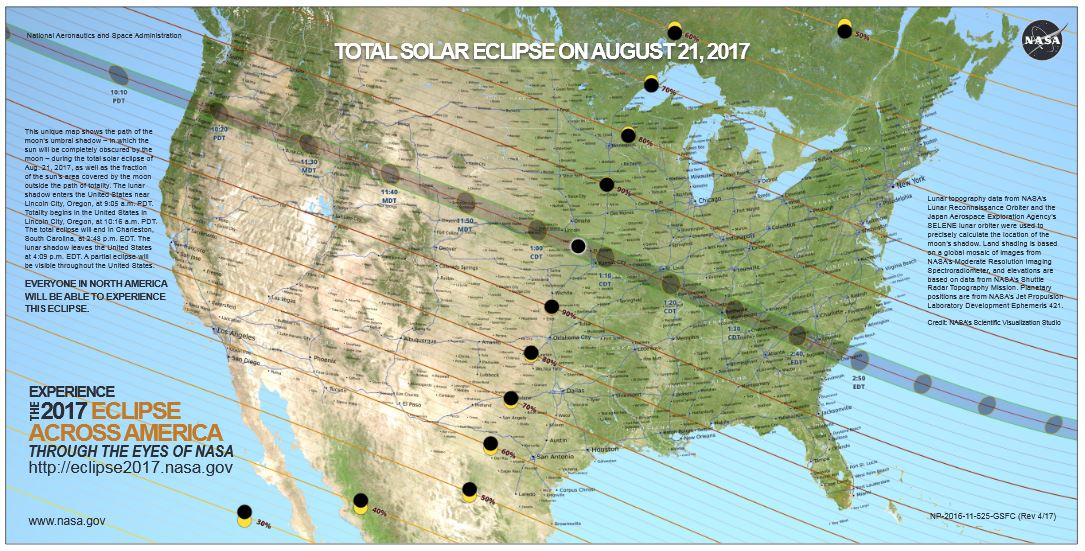
Path of Totality. NASA image.

Path of Totality. NASA image.

On August 21, 2017, a total eclipse of the sun will be visible as it passes across the United States from Coast to Coast. This is the first time an eclipse has been visible from coast to coast since 1918. I have seen partial eclipses, and they are a somewhat interesting phenomenon. However, I have never witnessed a total eclipse of the sun, and my family plans to travel to Nebraska to view it.

The total eclipse will be visible only on a band about 70 miles wide stretching from Oregon to South Carolina.  If you are not within this band, you might not even notice the eclipse if you’re not watching for it.  But within this band, the sky will become dark, stars will be visible, and only the sun’s corona will be visible.

During the approximately two minutes of totality, it is safe to view the sun with the naked eye.  But even if only a tiny portion of the sun is visible, then it is necessary to use eye protection.  Therefore, if you are planning to view the eclipse, two things are necessary.

1.  Get Your Eclipse Glasses!

First of all, you will want to get a set of eclipse glasses, such as the ones shown here.  With these glasses, which cost about $2, you will be able to safely view the eclipse if you are not in the path of totality, or if you want to look at the sun before and after totality.

During a 2015 partial eclipse in England, there was a shortage of the eclipse glasses.  In the days leading up to the eclipse, thousands searched in vain to find a pair, but there were none available, or they were available only at grossly inflated prices.  These glasses are still readily available online at reasonable prices.  I recently purchased 10 pairs of the glasses shown here, and they were shipped to me in about a week.   The total price for 10 pairs, including shipping, was about $17.  I’ll post a review in a few days, but they appear to be well made for what they are, and they have the appropriate ISO safety certification.

Unfortunately, I don’t know anyone else who has ordered in advance.  I suspect that, just like in England, there will be a huge demand at the last minute.  Stores won’t have them, and it will be too late to order online, or online suppliers will also run out.  Therefore, I strongly recommend that you order now while they are still available.  The set of ten that I ordered can be ordered from the following Amazon link:

Numerous other options are available on Amazon at this link.

In the Twin Cities area, I am only aware of these stores selling eclipse glasses.  They are:

2.  Make Your Hotel Reservations!

The other item you will want to consider is traveling to view the eclipse.   The partial eclipse that will be visible in most of the United States is certainly interesting, but for most, the total eclipse, visible only in a 70 mile wide band, is a once in a lifetime experience.  Most Americans are within a day’s drive, and it’s certainly worth the drive.  Surprisingly, some hotel rooms are still available, even though many cities along the path have been booked solid for months.  My family will be staying in Hastings, Nebraska, although that city is now completely sold out.

If all else fails, I would recommend simply driving to the path of totality, and sleeping in your car if necessary.  However, rooms are still available in many cities on and close to the path of totality.  The following table will give you some idea of what is available.  As you can see, the last hotel room in Casper, Wyoming, is a modest motel going for $800 a night.  But even though rooms are filling up fast, the following table gives you some idea of what is available.

This table shows availability at Hotels.com, as of June 16.  As you can see, many cities still have bargain hotels available.  This will certainly change as the eclipse gets closer, so. I encourage you to do as I did and make your reservation now.

I have included a link to the least expensive hotel in the city.  In some cases, this hotel might be a few miles from the path of totality, so you will still have to drive to the location of the eclipse.  But by booking a nearby hotel, you will make the process much easier, since you won’t have to worry about driving all night or sleeping in your car.  This chart shows availability for the night of August 20, the night before the eclipse.  The time of the eclipse will vary by location, but will be around midday on Monday, August 21.

As of today, inexpensive rooms are still available in Lincoln, NE, Kansas City, MO, Columbia, MO, Jefferson City, MO, St. Louis, MO, Paducah, KY, Nashville, TN, Greenville, NC, Columbia, SC, and Charleston, SC.  But I guarantee that will no longer be true in a couple of weeks!

Before I made my own hotel reservation last year, I did check on campground availability.  At that time, the campgrounds I checked were already sold out.  However, you may wish to check on campgrounds, including state parks on or near the path of totality.  (See the list of Nebraska State Parks at the end of this post.)

The links below are to the least expensive hotel in the area, as of June 16.  There might be other hotels that are more suitable or closer to the path of totality.  But this will give you an idea of what is available.

For constantly update hotel information, please visit the following posts:

City Lowest price City Percent Booked Link to Least Expensive Hotel
Salem, OR Not Available 100.00%
Jackson, WY Not Available 100.00%
Casper, WY $801 96%
1st Interstate Motel
Glendo, WY Not Available 100.00%
Alliance, NE Not Available 100.00%
Grand Island, NE Not Available 100.00%
Lincoln, NE $43.00 76.00%
Americas Best Value Inn Lincoln Airport
Kansas City, MO $42.00
Super 8 Lenexa Overland Pk Area
Columbia, MO $43.00 78.00%
Frontier Motel
Jefferson City, MO $50.00 Almost 100%
California Motel
St. Louis, MO $39.00
Motel 6 Hazelwood
Cape Giraredeau, MO Not Available 100.00%
Carbondale, IL Not Available 100.00%
Paducah, KY $180.00 98.00%
Wingfield Inn
Nashville, TN $50.00 72.00%
Super 8 Nashville Downtown
Greenville, NC $44.00
Days Inn Washington NC
Columbia, SC $42.00 74.00%
Budget Inn Express-columbia
Charleston, SC $60.00 93.00%
Econo Lodge North


Nebraska State Parks

It does not appear that there are any reservable campsites at Nebraska State Parks in the path of totality. But the following Nebraska State parks have sites available for reservation as of June 16. Most of these are north of the path of totality, some as much as a hundred miles or more. But for those visiting Nebraska from the north, one of these parks might be a good option, since you can camp there, and then drive to view the eclipse Monday morning.

  • Branched Oak SRA
  • Calamus SRA
  • Chadron SP
  • Eugene T. Mahoney SP
  • Fort Robinson SP
  • Fremont SRA
  • Lake Wanahoo State Recreation Area
  • Lewis and Clark SRA
  • Louisville SRA
  • Niobrara State Park
  • Platte River SP
  • Ponca SP
  • Rock Creek Station SHP
  • Two Rivers SRA
  • Willow Creek SRA


Lunar Eclipse of July 15, 1916

A partial lunar eclipse took place on this date one hundred years ago, f July 15 1916.  The eclipse was notable for the effect it had on Sir Ernest Shackleton’s Imperial Trans-Antarctic Expedition, an attempted crossing of the Antarctic continent.  The expedition consisted of two parties.  One party, led by Shackleton aboard the Endurance, was to make the crossing from the Weddell Sea.  This party was the most famous, since after the loss of the ship, the party had to travel to Elephant Island, then to South Georgia island, and finally make a dangerous land crossing to a whaling station on the other side of that island.

 A man, fresh-faced with dark, brushed-back hair, seated among a group. He is wearing a naval officer's uniform with a high, stiff collar

Aeneas Mackintosh, Ross Sea party commander. Wikipedia image.

The other party was to enter the continent from the Ross Sea, and was led by Aeneas Mackintosh.  This party would head inland and establish depots for the party making the crossing.  In 1916, five of this party were stranded, and needed to reach the relatively safety of a hut at Cape Evans.  An attempt was made in May, but the ice was too thin.  They had to wait for colder weather, which also meant darkness.  The weather was bad during the full moon of June, but on July 15, conditions seemed good.  But when the moon rose, the men were surprised to find that it was about to be eclipsed.  Fortunately, even though the eclipse continued for two hours, it was only partial, and enough light remained to make the journey.

Read More At Amazon


Click Here For Today’s Ripley’s Believe It Or Not Cartoon


Victory Eclipse of 1945

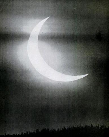
1945EclipseSeventy years ago today, July 9, 1945, a narrow strip of Idaho and Montana experienced a total eclipse of the sun.  From its sunrise beginning in the northwestern United States, the path of totality passed through Canada, Greenland, Scandinavia, and the Soviet Union. The photo here was taken near Butte, Montana, were the sun rose almost fully eclipsed, with totality a few minutes later. The photo was taken by Peter A. Leavens, and appeared in Life Magazine on July 23, 1945.

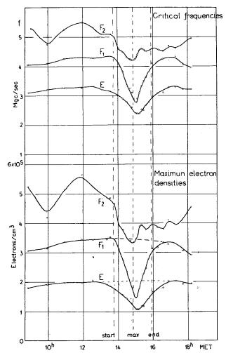
Critical frequency during eclipse.

Critical frequency during eclipse.

Ionospheric scientists at Tromsø, Norway, only two moths after liberation, took the opportunity to measure the effects of the eclipse on the ionosphere. Their results show a pronounced dip in the critical frequency during the eclipse.

Interestingly, their report also notes that the Germans had an ionospheric station at Kjeller, used to determine radio communication frequencies after the war. When the station was taken over by Allied forces, the German peronnel were ordered to continue their work, and observations were made at that station as well.

Click Here For Today’s Ripley’s Believe It Or Not Cartoon


Eclipse of April 7, 1940

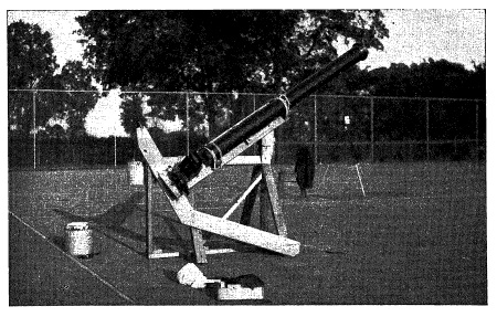
1940EclipseSeventy-five years ago today, April 7,  1940, an annular eclipse occurred, the center line of which passed through Texas and the southeastern United States.  Professor N. Wyman Storer of the University of Kansas took the opportunity to travel to Conroe, Texas, the closest point on the center line. There, he and assistants set up the University’s 6-inch refractor, shown here, on the tennis court of the Conroe High School, where he captured a number of good photographs of the eclipse.  The telescope was acquired by the University for $1000 in 1885, and was still in use as late as 1968.  The mount shown here was made of lumber, and cost $3.  The photos taken during this expedition can be found in the August 1940 issue of Popular Astronomy.

Click Here For Today’s Ripley’s Believe It Or Not Cartoon


WCCO and the Solar Eclipse of 1925

WCCOElcipse

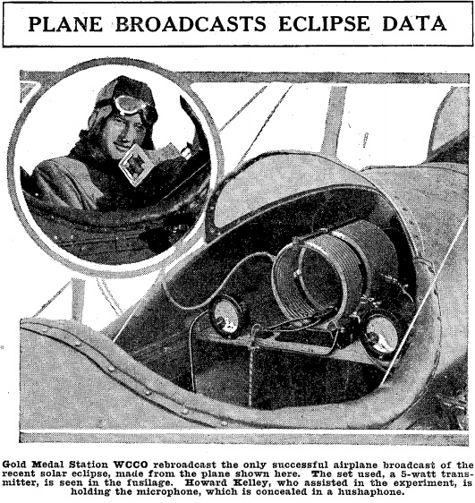
Ninety years ago today, the March 7, 1925, issue of Radio Digest carried this photo of an airplane used by WCCO radio in Minneapolis to carry “the only successful airplane broadcast of the recent solar eclipse.”

The plane was equipped with the 5-watt transmitter shown here.

The eclipse, which took place on January 24, 1925, had been visible in Northern Minnesota, and then moved over the Northeastern United States and then the North Atlantic. Its shadow had passed over Manhattan, where the path of totality was above 96th Street. Those below 96th street experience only a partial eclipse.

The film below shows film of the eclipse as seen from a Navy dirigible.

https://www.youtube.com/watch?v=l7XPjfCaltw

As I reported in an earlier post, the station had recently adopted the WCCO call sign, having previously been known as WLAG.  Another photo of the event can be found in WCCO’s 40th Anniversary album.


Radio and the Longitude Problem

RadioLongitude

The wireless telegraph  solved the Longitude Problem once and for all.    Many maritime disasters over the centuries were the result of sailors not knowing their longitude. Determining latitude is relatively simple. From any position on earth, it is easy to determine the local time by observing the sun or stars. When the sun is at its highest point for the day, this is, by definition, noon local time. The sun’s altiude at that time can be used to quickly determine the observer’s latitude.

Longitude, however, was a much more difficult problem. With instantaneous communication, it’s trivially simple to determine longitude. The observer merely determines local noon, and then compares that with the local time at a known longitude. The difference in time can quickly be converted to difference in longitude. If it is noon at my location, and I know that it is 6:00 PM at Greenwich, then I instantly know that I am 90 degrees west of Greenwich. The time diference is 6/24 of one day, which is 1/4. Therefore, the difference in longitude is 1/4 of 360 degrees, or 90 degrees.

Of course, instantaneous communication was not availalbe for most of the history of navigation. Therefore, the problem remained formidable. It wasn’t until the late 1700’s that sufficiently accurate chronomoters became available. And even then, a backup method (careful observation of the eclipses of known stars by the moon) involving laborious calculations was required.

These problems were  solved by the use of wireless time signals. A mariner could set his chronometer accurately (generally, to about a tenth of a second) by use of time signals broadcast by stations such as NAA in the United States or the Eiffel Tower in France.

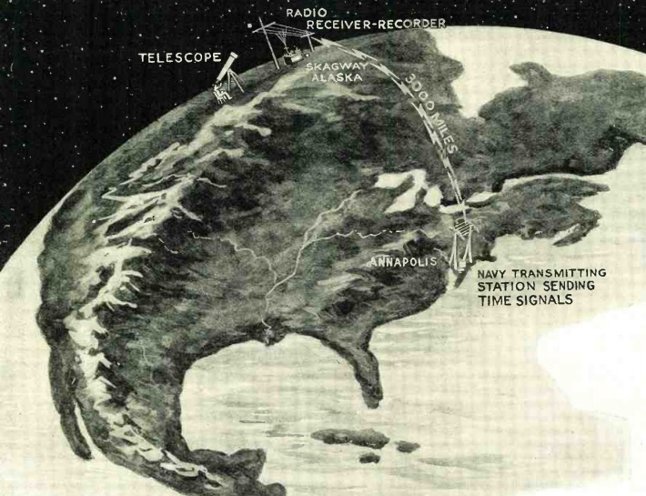
But even as recently as 90 years ago, this problem was still receiving attention, as shown by the article in the November, 1924, issue of Radio News. Listening to the time signal by ear and noting the time on the chronometer was accurate enough for maritime navigation. But for land surveying, a more precise automated method was necessary. Telegraph lines could be used, but the relays used in long lines introduced a delay. Radio was ideal, since the only delay was the speed of light, and even that could be accounted for. The article explains how the time radio time signal from the naval observatory was graphed along with the time from a locally calibrated chronometer. The result was a very accurate indication of the time difference, and thus the longitude difference, between the two locations.

The article shows how the time signal from Annapolis, Maryland, was used to determine exact longitude in Skagway, Alaska, 3000 miles away.

Read More at Amazon