
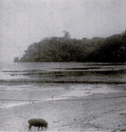
 Seventy-five years ago today, the October 5, 1942, issue of Life magazine included this nondescript tourist photo as an example of something the government desperately needed. Specifically, the Office of Strategic Services (OSS), the forerunner of the CIA, was requesting tourist photos from around the world for use in invasion planning.
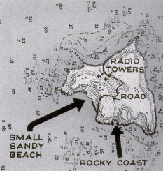 To illustrate the point, they provided this map of hypothetical Fitzhugh Island, the site of a powerful radio transmitter being used by the enemy. To silence the radio station, an invasion was required. The location of the radio station was clearly visible on the prewar map. But many details necessary to mount the invasion were unknown. In particular, it was not known whether the beach was suitable for landing the invading forces.
This is where prewar tourists got involved. In a dusty photograph album somewhere in America, there probably existed photographs taken during a prewar vacation to Fitzhugh Island. That photograph, shown above, needed to get into the hands of the OSS to confirm that the beach was suitable.
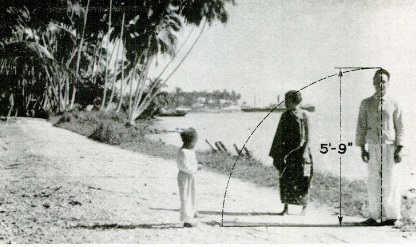
Many photographs would be useful for things like determining the composition of roads (and whether they would support a tank) and their width. The photo shown below could be used to measure the width of the roadway, since the tourist’s height was known or could be readily estimated. The image of the ship in the background also provided valuable clues as to the harbor’s suitability for invasion.
To get these photographs where they were needed, the OSS was asking for “all photgraphs (stills and movies) taken by tourists outside the U.S., in Europe, Asia, the Philippines, South Seas, Africa. All types are useful, even family groups.” To facilitate handling, the magazine asked those in possession of such photos to write for a questionaire (but to complete the questionaires before sending any photos). The magazine provided the address of the OSS as P.O. Box 46, Station G, New York, N.Y.
After the hypothetical case of Fitzhugh Island, the magazine turned to an actual example of where such photos had been used. On February 27, 1942, British commandos under the command of Lord Louis Mountbatten launched Operation Biting, a successful raid against a Nazi RADAR at Bruneval, France, about twelve miles from Le Havre.
The BBC had previously broadcast a plea asking all people who had spent a holiday along the northern coast of France to send in any pictures they might have taken. Among the pictures that flooded in were the two shown below.
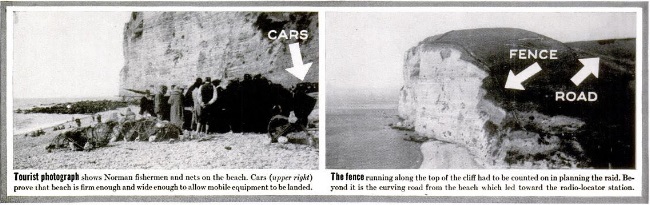
These photos showed some critical details necessary for planning the raid. The photo of fishermen on the left showed that there were cars on the beach, thus confirming that the sand would support mechanized equipment. And the landscape on the right revealed a fence and the exact location of the road to the station.