
Taking down my station after operating.
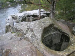
Glacial pothole at Interstate State Park. National Park Service photo.
On the Fourth of July, I did another activation for National Parks On The Air (NPOTA), an event in which amateur radio operators set up portable stations at National Park units and make contact with other amateurs at home. The event has been very popular, and there have been hundreds of thousands of contacts made from the parks. Even though I don’t live near an actual National Park, there are hundreds of National Park units around the country, many of which are close to home. Three of them are located in Wisconsin very close to the Twin Cities area. Those are the St. Croix Wild and Scenic River, the Ice Age National Scenic Trail, and the Ice Age National Scientific Reserve. The trail covers 1200 miles as it loops through Wisconsin, the river is the state’s western boundary, and the Scientific Reserve is made up on nine Wisconsin State Parks, one of which is Interstate State Park, located less than an hour from Minneapolis and St. Paul, MN. The trail and scientific reserve get their name from the geological features, since the landscape was carved out by the glaciers. The spot from which I operated was called the Pothole Trail, since it contains massive potholes carved into the rock by the action of rushing water as the glaciers receded.
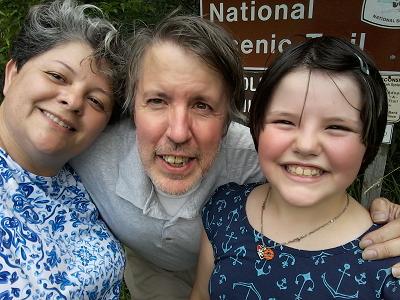
Myself and my assistants at the trailhead before starting the arduous quarter mile hike to the operating location.
In my earlier trip to scout out the area, I confirmed that there was a small area where the three National Park units came together. The park’s western boundary is the river, so any operation within 100 feet of the water qualifies as being from the river. Operation from the scenic trail must be within 50 yards of the trail, and the operating location must be reached using human power. For most of my river and park activations, I’ve operated from my vehicle. But in order to activate all three units simultaneously, I needed to reach the site on foot. In my earlier trip, I did confirm that there were spots within 100 feet of the water and 50 yards of the trail. I forwarded this information to ARRL, which made the spot a “threefer” for NPOTA purposes. This week, together with my wife and daughter, I set out to operate from that small area. (My son is at scout camp this week at Tomahawk Scout Reservation, which coincidentally also lies along the Ice Age Trail near Rice Lake, Wisconsin.)
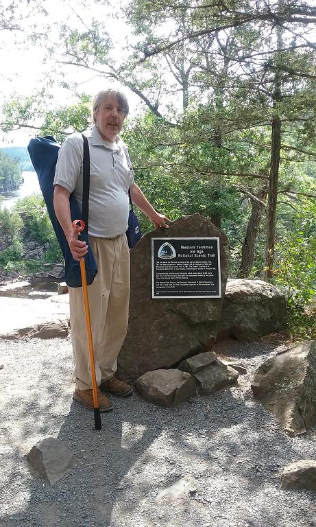
At the marker showing the western terminus of the trail. My station is contained in the blue bag over my left shoulder. The golf ball retriever served as walking stick and antenna support.
My station consisted of my Yaesu FT-817, powered by a 12 volt sealed lead acid fish finder battery, The antenna consisted of a 20 meter inverted vee supported by my trusty golf ball retriever in the center and tied to some convenient trees with string. I carried a folding chair, and my operating table consisted of a boulder conveniently left behind by the last glacier.
As I was setting up, I ran into another ham, KD0IYR, who happened to be climbing in the area. To help ensure I made my required ten contacts, I handed him my $30 Baofeng UV-5R and worked him twice, on 2 meters and 70 cm. I then worked my wife, KC0OIA, on both of those bands. With four contacts out of the way, I only needed an additional six to make the activation official.
After setting up my antenna, I started calling CQ, and had my wife spot me on DXSummit.fi. Within seconds of her posting the spot, I had callers. I made ten contacts in the next fifteen minutes. Unfortunately, after fifteen minutes, the spot disappeared off the DX cluster page, and I didn’t get any more replies. I made my ten contacts, even without counting the four orchestrated ones, but it’s still somewhat disappointing how many chasers depend on the cluster, when there are easy units to be worked simply by tuning around and listening. My best DX was S58AL in Slovenia.
After things quieted down, I tuned around and worked K2M, one of the stations in the Thirteen Colonies operating event. Band conditions were not the best, but I did tune the phone band. I heard one other park on the air, but was unable to raise him before he had to QRT. I called CQ for a few minutes on SSB, but with no takers.
Click Here For Today’s Ripley’s Believe It Or Not Cartoon

Pingback: NPOTA: St. Croix National Scenic Riverway | OneTubeRadio.com
Pingback: National Parks On The Air: Appalachian Trail | OneTubeRadio.com