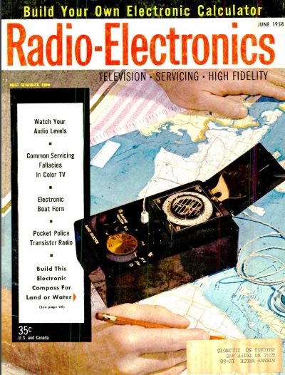
 Sixty years ago this month, the June 1958 issue of Radio Electronics carried the plans for this transistorized radio compass.
The circuit was nothing more than a superheterodyne receiver covering the standard broadcast band and, if desired, the longwave band. It was specifically designed for use as a radio compass. Any portable AM radio with a loopstick antenna can be used for the same purpose, although the magnetic compass mounted directly on the case made use of this one quite convenient.
The article specified that it was a worthwhile investiment for “people interested in outdoor activities such as motorboating, sailing, hunting, trapping, berry picking, camping, hiking or other activity where there is a possibility of getting lost.”
Even with this modest receiver, or even the most inexpensive AM transistor radio, the method of locating yourself is actually extremely accurate. All you need is an AM radio and a good map marked with the locations of local broadcast stations. The ferrite core antenna coil is mounted parallel to one of the sides of the case of the radio. Fortunately, the vast majority of inexpensive radios were also built this way. The antenna is very directional, and produces a sharp null when the length of the antenna is pointed directly at the station.
To use as a direction finder, the radio is placed on the map, and with the compass, the map is oriented to the map. The radio is turned until the signal fades out. At that point, the side of the radio is used as a straightedge, and a line is drawn through the radio station.
This process is repeated with a second station. The point on the map where the two lines intersect is your location.
I’ve tried this method using an inexpensive transistor radio, and the accuracy is astonishingly good. In an urban area, I can generally find my location within a few hundred yards. At night, using distant signal clear channel stations, I can determine my location within about twenty miles.
The exact location of a radio station’s transmitter (which might be different from its city of license or studio location) can be looked up at the FCC website. Once stations are found, their latitudes and longitudes can be plotted on a map, or even on graph paper. With a bit of practice, you will be able to very accurately determine your location with very minimal equipment.
Of course, a GPS receiver will give more accurate results much more easily. But the GPS receiver depends on GPS satellites being operational, which might not be a given in some emergency situations. Also, if the sky is obscured by heavy foliage, a signal might be unavailable, but AM radio signals would come in loud and clear via ground wave. As long as at least two AM radio stations are on the air, an AM radio can tell you your location quite accurately.

I’ve found that a few of the local broadcast stations seem to give an inaccurate bearing. It’s possible that some of them moved their transmitter site without telling the FCC, or possibly that station’s signal is being reflected by some nearby object. To get a precise location, I plot several bearings on the map, and ignore the one that seems not to intersect the others. The other lines are generally very close together, and I estimate my position based upon where those other lines converge.
More information about this method of direction finding can be found at this post.