 June 4, 2016 was American Hiking Society’s National Trails Day®. Since many trails are units of the National Park Service, they are taking part in National Parks On The Air (NPOTA), an event in which amateur radio operators set up portable stations at National Park units and make contact with other amateurs at home. The event has been very popular, and there have been hundreds of thousands of contacts made from the parks. The North Country National Scenic Trail qualifies as a “National Park,” allowing me to operate from one of the Minnesota state parks crossed by the trail. The North Country Trail extends from eastern New York to North Dakota. As the trail passes through Minnesota, it becomes the Superior Hiking Trail, which runs from Jay Cooke State Park along the north shore of Lake Superior to Grand Portage.
On National Trails Day, a group of hams put together an event called Light Up The Trail in which stations were set up at various locations in all of the states along the North Country Trail. As I did a couple of weeks ago, I operated from Jay Cooke State Park in Minnesota, about 25 miles south of Duluth.
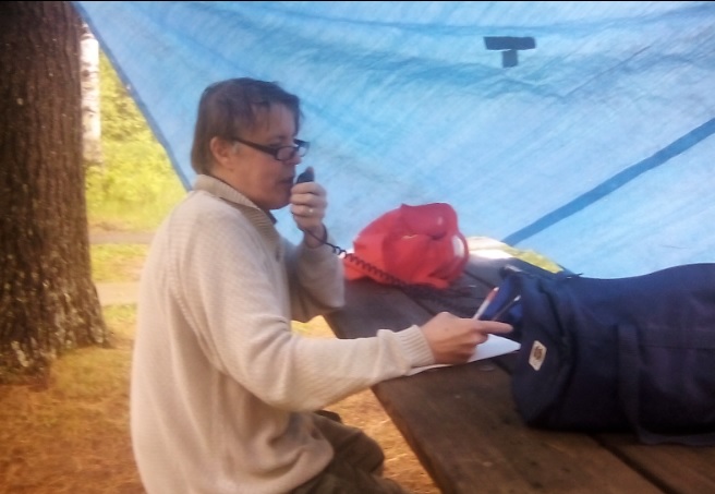
The weather wasn’t quite as cooperative as it had been with my previous activation, since there was a light rain when my son and I arrived at the park. Undaunted, we moved a picnic table close to two trees what would serve as a support for a tarp. I used my trusty golf ball retriever as a tent pole on one corner, and secured the other corner to the table itself. A few taut line hitches had the protective shelter up in a few minutes, and I was ready to get on the air. My original plan was to set up dipoles for 40 and 20 meters, but with the rain coming down, I decided to stick to 20 meters only, since the total antenna length was only 32 feet. I used an inverted vee with the center supported by the golf ball retriever, and the ends tied to a tree and another picnic table. The radio consisted of my Yaesu FT-817, powered by a 12 volt sealed lead acid fish finder battery,

Old fort at Crown Point, New York, the eastern terminus of the North Country Trail, and my first contact. Wikipedia photo.
The activation was shorter than I had planned, but I managed 16 contacts in less than an hour of operating. My very first contact was with N1NDN who came back to my voice CQ from the eastern end of the trail at Crown Point State Park on Lake Champlain, New York. He had a very good signal, and didn’t seem to have any trouble copying my 5 watt signal. I also made contacts with two other parks, W3OK at Delaware Water Gap National Recreation Area, and W5NO at Gulf Islands National Seashore.
My last contact was with AA0AW, who was operating from the North Country Trail in Duluth. After packing up, we made a short stop at their location for an “eyeball QSO.” A group of Duluth hams had a large multi-operator operation, and had worked about 150 contacts by the time we stopped by.

Swinging Bridge prior to 2012 flood. Wikipedia photo.
The site from which I was operating, Jay Cooke State Park, lies next to a rapids of the St. Louis River. Because the rapids is impassible by canoe, it was the location of a portage used by both Native Americans and European fur traders, and remained in use until the 1870’s when a railroad was built in the area. The portage was an important link between the Great Lakes and the Mississippi River. From the portage, travelers could navigate the river to Savannah Portage, a six-mile link to the Mississippi watershed. Jay Cooke park was formed in 1915 and remained largely undeveloped until the 1930’s when the Civilian Conservation Corps built a number of structures. I was right next to two of these. The most iconic structure in the park is the Swinging Bridge, a pedestrian bridge crossing the river. A

St. Louis River, just upstream from the park. Wikipedia photo.
rickety version was in place as early as 1924 (a picture is available at this site), until 1933 when the more substantial suspension bridge was built by the CCC. That bridge endured until a massive flood in 2012, but the bridge has since been rebuilt to its 1930’s specifications.

River Inn Visitor Center, Jay Cooke State Park. Wikipedia photo.
My operating location was right behind the River Inn, a picnic shelter and small museum, also built by the CCC. I toyed with the idea of operating from inside the building, which had a roaring fire going in its fireplace. But unfortunately, there was no convenient way to get my antenna cable outside, so I decided to go with my expedient blue tarp.

Back of the River Inn from my operating location. The golf ball retriever is visible holding up the tarp and antenna.
The 2012 flood which destroyed the bridge continues to have an impact. Minnesota Highway 210, which serves as the access to the park (and has the distinction of being a Minnesota state highway running through a small section of Wisconsin) is still closed east of the park. The $21.3 million reconstruction of the highway is scheduled to be completed in October 2016.
Here’s some raw video shot by my son, which will give you an idea of my operating location:
Click Here For Today’s Ripley’s Believe It Or Not Cartoon

Pingback: National Parks On The Air: Appalachian Trail | OneTubeRadio.com
Pingback: NPOTA and WWFF | OneTubeRadio.com