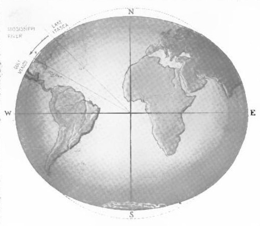
This interesting illustration from the June 1921 issue of New Science and Invention demonstrates that the Mississippi River (or any river flowing toward the equator) actually flows uphill. The Earth is not a perfect sphere. There is an equatorial ring about 13.5 miles deep. In other words “sea level” is not constant. It is higher at the equator than it is at the poles.
In the case of the Mississippi, sea level at the mouth of the Mississippi is 6,373,159 meters from the center of the Earth. Sea level at the source of the Mississippi is 6,366,524 meters. The difference is 4.12 miles. The source of the Mississippi, Lake Itasca, is 1400 feet above sea level, and the mouth is, by definition, zero feet above sea level. So we think of all of that water flowing downhill 1400 feet. But it is actually flowing against the force of gravity, going four miles uphill. The force that keeps the water flowing is actually the centrifugal force of the earth’s rotation.
If we did measurements of the flow of the water, only the effect of gravity would be observable. But that’s only because we’re using “sea level” as our reference in the first place. And the difference in sea level is itself caused by that same centrifugal force. So its effect is cancelled out in the measurements that we make.
To put it another way, if we lowered Lake Itasca by 1400 feet, then the water in the river would stand still, even though the New Orleans end was four miles higher. It would be held in place by the Earth’s rotation. When we raise Lake Itasca, the much smaller additional force of gravity is what causes the actual motion of the water. Counter-intuitively, the gravitational force is much smaller than the centrifugal force. This is demonstrated by the fact that the centrifugal force lifts not only the water, but also the entire crust of the Earth, more than 13 miles at the equator.
If we were to stop the rotation of the earth, the centrifugal force would disappear, and gravity would take over. The water would be drawn toward the center of the earth. In the case of the Mississippi, the water in New Orleans (and all of the ocean water behind it) would flow downhill the four miles to Lake Itasca.
(And yes, for the purists, I’m already aware that there’s really no such thing as centrifugal force.)
References
NOAA, Geodetic Bench Marks, Appendix B:
Many people are willing to accept a sphere as being a suitable geometrical figure of the earth. This, however, can lead to some patent absurdities if carelessly applied to the principles of levels. There is the case of the flow of the Mississippi River. Considering the 1535 kilometer section from the mouth of the Ohio River (Cairo, Illinois) to Head of Passes, Louisiana, engineer’s levels indicate that the mid-stage elevation of the water surface drops approximately 91 meters…. This agrees with common sense but, to the unwary, is a bit difficult to reconcile with the fact that Head of Passes is 2643 meters farther from the center of the earth than the Mississippi River is at Cairo, Illinois. This could lead to the conclusion that the river is running uphill at a rate of 1.7 meters per kilometer, instead of downhill at a rate of 6 centimeters per kilometer. (The explanation of this absurdity lies in the fact that the meridional section of the earth is approximately elliptical.)
This can, of course, be countered by the engineer with the statement that he never meant for his levels to define the distance of a point from the center of the earth. When pressed for another definition, he will mutter something about height above “Mean Sea Level.” This can, however, be an elusive concept unless carefully defined.